Things to do
& see
There is lots to see and do on Canna, whether your interest is in nature, history or culture. Canna has an abundance of wildlife, wild flora, over 1,000 sites of historic interest and a rich Gaelic heritage.
Not bad for an Island only 5 miles by 1 mile wide. You will not be disapointed....
Highest points on Canna and Sanday are:
-
Carn na Ghaill – 210 metres – North cliffs,
Grid ref. NG263064
-
Tallabric – 59 metres – SW corner of Sanday,
Grid ref. NG264041

Walking on Canna
Shorter Walks
All shorter walks lead off from the main road from the pier which follows the shoreline around the harbour
Prison Rock and Black Beach
From the bend in the road just east of the shop and café, take the rough track up the hill between the farm walls to the old barn at Coroghon. Beyond, top left of the rock stack, you see the 'strange fort' – where it is said that Marion Macleod was imprisoned in the late 17th century for being unfaithful to her husband. Or was it simply a beacon..? maybe a bit of both?
Please do not try to climb the stack, as the structure is unsafe. Below the barn is the peaceful volcanic black sand beach.


Sanday Beach | Traigh Bhàn
Follow the road around the harbour to the bridge connecting Canna to the Isle of Sanday. On the far side of the bridge, by the fisherman's shrine – turn right to follow the shoreline (watch your step) to the beautiful white sand beach of Traigh Bhàn. A perfect spot just to relax, or take a picnic – please take any litter away with you.
The sandy fields behind the beach are resplendent with flowers in the summertime. An early morning visit might reward you with a sight of otter footprints in the sand – or simply pick colourful sea shells from the strandline.
A'Chill and Celtic Cross
From the harbour road, take the field gate before the Square next to St Columba's Chapel (worth a look inside), following the sign to A'Chill. Follow the field uphill, around the side of Heron Rock, to the information board just through the next field gate – then the path through the small woodland, past the grave of John Lorne Campbell (Fear Chanaidh – 'Man of Canna'). Entering the next field, you are on the site of A'Chill, once the main settlement on Canna, of which little now remains.
You will find, however, the remains of the early Christian cross, dating from the 7th - 9th century, with its many decorated symbols. Two arms are sadly missing, said to be a result of cannonball target practice during the Napoleonic wars.
Further up the field to the left, on a low mound, stands the 'Punishment Stone'. Local legend tells that offenders would have their thumb wedged firmly into the hole on the side, and left to ponder their misdeeds for a period befitting the crime. Head down to the nearby fence, cross the stile, and walk past the old graveyard to retrace your steps to the track.


Saturnino's Path and Compass Hill
From the road, either walk through Canna House garden, exiting by the gate in the east wall – or follow the path from the community shop alongside the garden wall past the polytunnel – until you reach a blue waymarker at a junction in the path.
To the left takes you up by Tighard Guest House – instead, follow the path to the right. This narrow path runs through woodland, carpeted with snowdrops, wild garlic, bluebells and ferns depending on the season, before descending to a gate into the field. Cross the field to the gate adjacent to Coroghon Barn, to take the track leading back to the road – or, (for the more adventurous) follow the fence uphill and through the field gate, then climb past the radio mast to take in the view from the high point of Compass Hill, so called from the magnetic rocks that play havoc with compass readings.

The Three Churches


From the pier, take the road around the harbour. After a short distance on the the right, you encounter the Presbyterian 'Rhu Church' , or more affectionately 'Rocket Church'. Based on an Irish design, it was built in 1911 as a place of worship for the Thom family, owners of Canna at this time,which had traditionally been a predominately catholic island.
After about 15 mins walk along the road, just before the Square, you will find St Columba's Chapel, bearing a white cross on the gable. Originally built after 1770, this was the main place of catholic worship, until 1897 when the church on Sanday was built. For a while, it became the shop and post office, until 1965 when it was rededicated as a chapel, still in use today.
Cross the bridge onto the island of Sanday. Follow the new road to its end and onto the imposing building of St Edward's Chapel. Built in 1890, it was funded by the Marchioness of Bute in memory of her late father, Lord Howard of Glossop, providing a landmark and a place of worship for the many fishermen visiting Canna at this time. Renovated for use as a study centre in 2000, the problems of water ingress were never successfully solved, the building currently not in use.
Longer Walks
Canna may appear a relatively small island, but has significantly rough terrain and steep cliffs. Add in high winds and rain, this can make conditions pretty inhospitable. Longer walks beyond the harbour are best attempted in calm weather, with warm ,waterproof clothing, refreshment and an Ordnance Survey map.
On good days, walkers will be rewarded with fine views of surrounding islands.
Souterrains and 'King of Norway's Grave'
From the harbour road, take the track leading off by Jane's Cottage toward Tarbert (red waymark). Follow the track for approximately 3km, until it drops steeply downhill to a sharp hairpin bend. Leave the track here, following the red waymark over rough ground, up a wide gully leading toward the north of the island.
Continue, crossing a small wooden plank bridge until you see a small, grassy green field ahead and slightly to your right, with a stone dike running alongside. Here you will find the Souterrains – two small underground chambers, possibly dating back some 2,000 years. No-one is really sure what function these had – storage? a hiding place? or religious?
From here, either retrace your steps – or in good weather continue toward the north side of the island to look down on the 'King of Norway's Grave' – a large rectangular stone enclosure on the peninsular of Rubha Langanais. The adventurous might wish to return east along Canna's north cliffs as far as Compass Hill before descending via Coroghon to the harbour.


The West End
Follow the Tarbert road to its end by the old barn and shepherd's bothy. From here, walk along the southern cliffs to Garrisdale point, and return along the north cliffs back to Tarbert. On the way, look down upon the significant historic landmarks of the Nunnery, Dun Chanaidh and Dun Teadh, and the old township of Garrisdale.
Best to allow a full day in good weather for this walk.
The Puffin Stacks
Late April to July, when the birds are present cross the bridge onto the island of Sanday. Follow the road out as far as St Edward's Chapel. From here, walk along the field wall to the south side of the island, then follow the coast until you reach the spectacular sea stacks of Dun Mor and Dun Beag. Here you will find the main colony of puffins – hundreds during the breeding season – and the cliffs which are home to nesting fulmars, kittiwakes, guillemots, razorbills and shags.
You can return via the lighthouse and north shore of Sanday, or 'cross-country via the lochan of An-t Oban – but watch out for the nesting Great Skuas which will dive bomb you mercilessly during the breeding season!
(A walking pole is useful)


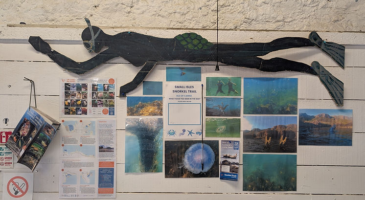
SMALL ISLES SNORKEL TRAIL
The Small Isles Community Council have been working with Scottish Wildlife Trust to launch our very own Small Isles Snorkel Trail. There are 6 trails across the 4 islands for visitors to explore and engage with our living seas.
We are surrounded by the sea and there are a myriad of species that can be observed while taking to the water with a snorkel kit.
Creatures you might see are: shore crabs, jellyfish, a variety of seaweeds, sea sponges, hermit crabs, seals, anenomes, sea grass and many many more!
What you see will change throughout the year and the seasons. The average sea temperature in the Summer is 14 degrees
Here in Canna, we have a trail at Coroghan Bay and a trail at Tarbert Bay. The leaflet for the trails gives you all the information you need to get out there and explore.
The printable Small Isles Snorkel Trail leaflet gives you all the information you need to get out there and explore. It can be found here.
Also check out the Scottish Wildlife Trust's other snorkel trails around Scotland here.


Coroghan Bay

Tarbert Bay


After you've been for a snorkel, head to The Shearing Shed and write what you've seen in the sea on our Snorkel Trail board!
You can also look up anything you need to identify!